Log in
All resources
Create a design
1,097 Free Artworks of Coats Of Arms On Maps
bibliothèque nationale de france
a map of the british empire in america with the french and spanish settlements adjacent thereto
maps by willem and johannes blaeu
paper
british museum
german renaissance,northern renaissance
geographia universalis (1545) in the british museum
ptolemy
hans holbein the younger
baroque
maps of châteaudun by braun & hogenberg
maps of chartres by braun & hogenberg
maps of aachen by braun & hogenberg
bibliothèque nationale de france
maps of dordrecht by braun & hogenberg
bibliothèque nationale de france
history of schwäbisch hall
baroque
a map of the british empire in america with the french and spanish settlements adjacent thereto
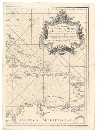
1730s maps of the caribbean
a map of the british empire in america with the french and spanish settlements adjacent thereto
1730s maps of central america
maps in the rijksmuseum amsterdam
18th-century maps of japan
context files from gallica
pieter van der keere
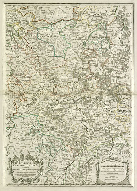
map of the circle of the rhineland by sanson
1730s maps of rhineland-palatinate
juan de la cruz cano y olmedilla
1750s maps of the caribbean
1760 maps of asia
baroque painting
a map of the british empire in america with the french and spanish settlements adjacent thereto
1730s maps of the caribbean
le royaume de france distingué by guillaume sanson
1724 maps of france
maps of emden by braun & hogenberg
bibliothèque nationale de france
old maps of gâtinais and sénonais
maps by willem and johannes blaeu
le royaume de france distingué by guillaume sanson
1724 maps of france
1700s maps of rhineland-palatinate
maps of vangiones by sanson
maps in the stadsarchief amsterdam
engravings by cornelis bogerts
bibliothèque nationale de france
1698 map of evesché de meaux
bibliothèque nationale de france
1698 map of evesché de meaux
magni ducatus lithuaniae
maps facing west
1700s maps of the tsardom of russia
1700s maps of eastern europe
le royaume de france distingué by guillaume sanson
1724 maps of france
magni ducatus lithuaniae
maps facing west
17th-century maps of nord (department)
maps of artois
maps by willem and johannes blaeu
1640s maps of belgium
17th-century maps of amsterdam
1620s maps of the netherlands
maps of county armagh
1760s maps of ireland
geographia universalis (1545) in the british museum
german renaissance,northern renaissance
geographia universalis (1545) in the british museum
german renaissance,northern renaissance
17th-century maps of maastricht
baroque
maps of tønder by braun & hogenberg
maps of eutin by braun & hogenberg
maps of grenoble by braun & hogenberg
maps of romans by braun & hogenberg
maps of rotterdam by berckenrode
baroque
maps of amsterdam by braun & hogenberg
bibliothèque nationale de france
old maps of emmerich am rhein
baroque
maps of groningen by braun & hogenberg
bibliothèque nationale de france
maps of nevers by braun & hogenberg
maps of autun by braun & hogenberg
john rocque's 1748 map of london and adjacent country
remigius parr
old maps of plymouth and devonport
16th-century maps of england
china veteribus sinarum regio nunc incolis tame dicta
coats of arms on maps
maps by hendrik hondius the younger
maps of the county of mansfeld
maps of london by braun & hogenberg
bibliothèque nationale de france
old maps of utrecht (city)
baroque
maps of windsor by braun & hogenberg
maps of oxford by braun & hogenberg
lithographs in the british museum
lemercier & cie.
1660s maps of france
maps of lyonnais
maps of lisbon by braun & hogenberg (1572)
maps of cascais by braun & hogenberg
17th-century maps of transylvania
maps by willem and johannes blaeu
1680s maps of rhineland-palatinate
maps of vangiones by sanson
john rocque's 1748 map of london and adjacent country
remigius parr
maps of the course of the rhine by guillaume sanson
maps by nicolas sanson
17th-century maps of poitou
1660s maps of france
maps by willem and johannes blaeu
old maps of quercy
1670s maps of the iberian peninsula
georg widmann
maps of the principality of erbach
maps by pieter van der keere
a map of the british empire in america with the french and spanish settlements adjacent thereto
bibliothèque nationale de france
a map of the british empire in america with the french and spanish settlements adjacent thereto
bibliothèque nationale de france
a map of the british empire in america with the french and spanish settlements adjacent thereto
bibliothèque nationale de france
a map of the british empire in america with the french and spanish settlements adjacent thereto
bibliothèque nationale de france
a map of the british empire in america with the french and spanish settlements adjacent thereto
bibliothèque nationale de france
a map of the british empire in america with the french and spanish settlements adjacent thereto
bibliothèque nationale de france
a map of the british empire in america with the french and spanish settlements adjacent thereto
bibliothèque nationale de france
a map of the british empire in america with the french and spanish settlements adjacent thereto
bibliothèque nationale de france
a map of the british empire in america with the french and spanish settlements adjacent thereto
bibliothèque nationale de france
a map of the british empire in america with the french and spanish settlements adjacent thereto
bibliothèque nationale de france
a map of the british empire in america with the french and spanish settlements adjacent thereto
bibliothèque nationale de france
a map of the british empire in america with the french and spanish settlements adjacent thereto
bibliothèque nationale de france
maps of schwäbisch hall by braun & hogenberg
bibliothèque nationale de france
a map of the british empire in america with the french and spanish settlements adjacent thereto
bibliothèque nationale de france
maps by willem and johannes blaeu
17th-century maps of dombes
gouvernement général de picardie qui comprend la généralité d'amiens divisée en ses huit elections. avec l'artois, et les frontières des pays-bas. dressé sur les mémoires les plus nouveaux - par le... - btv1b59717521
bibliothèque nationale de france
gouvernement général de picardie qui comprend la généralité d'amiens divisée en ses huit elections. avec l'artois, et les frontières des pays-bas. dressé sur les mémoires les plus nouveaux - par le... - btv1b59717521
bibliothèque nationale de france
old maps of leiden
views of leiden
maps of hrodna by braun & hogenberg
bibliothèque nationale de france
cartouche (cartography)
maps by john rocque
old county maps of hertfordshire
maps by thomas kitchin
geographia universalis (1545) in the british museum
german renaissance,northern renaissance
media from regionaal archief alkmaar
vier noorder koggen (ambacht)
maps by willem and johannes blaeu
maps of the duchy of montferrat
a map of the british empire in america with the french and spanish settlements adjacent thereto
bibliothèque nationale de france
a map of the british empire in america with the french and spanish settlements adjacent thereto
bibliothèque nationale de france
maps of haarlem by braun & hogenberg
bibliothèque nationale de france
a map of the british empire in america with the french and spanish settlements adjacent thereto
bibliothèque nationale de france
geographia universalis (1545) in the british museum
german renaissance,northern renaissance
geographia universalis (1545) in the british museum
german renaissance,northern renaissance
geographia universalis (1545) in the british museum
german renaissance,northern renaissance
gouvernement général de picardie qui comprend la généralité d'amiens divisée en ses huit elections. avec l'artois, et les frontières des pays-bas. dressé sur les mémoires les plus nouveaux - par le... - btv1b59717521
bibliothèque nationale de france
gouvernement général de picardie qui comprend la généralité d'amiens divisée en ses huit elections. avec l'artois, et les frontières des pays-bas. dressé sur les mémoires les plus nouveaux - par le... - btv1b59717521
bibliothèque nationale de france
geographia universalis (1545) in the british museum
german renaissance,northern renaissance
maps of paris by braun & hogenberg
bibliothèque nationale de france
maps of provence by pierre-jean de bompar
bibliothèque nationale de france
17th-century maps of pembrokeshire
old county maps of pembrokeshire
geographia universalis (1545) in the british museum
german renaissance,northern renaissance
map collection of leibniz-institut für länderkunde
maps of portugal by fernando álvares seco
magni ducatus lithuaniae
maps facing west
johann stridbeck the younger
old maps of the tyrol
maps by jodocus hondius
maps by john speed
maps by jodocus hondius
maps by john speed
17th-century maps of carmarthenshire
17th-century maps of pembrokeshire
501 - 600 of 1,097
Next page
/ 11


![Gastinois and Senonois / [Blaeu], 1631](https://cdn.creazilla.com/illustrations/10001540570/gastinois-and-senonois-blaeu-1631-md.jpg)


![Rotterdam / [M. Merian], Matthäus Merian](https://cdn.creazilla.com/illustrations/10000529192/rotterdam-m-merian-matth-us-merian-md.jpg)


![Oxonium [...]; Vindesorium [...], between 1640 and 1645](https://cdn.creazilla.com/illustrations/10001544887/oxonium-vindesorium-between-1640-and-1645-sm.jpg)


